

GPS Jamming in the Baltic: What Ships Are Facing in 2026
Jamming and spoofing are now the background condition in the eastern Baltic. What they look like from the bridge, where they hit hardest, and what crews can do about it.
GPS jamming in the Baltic is no longer an occasional nuisance for shipping. In the eastern Baltic it has become the background condition every voyage is planned around — and the harder problem is not the jamming a bridge team notices, but the spoofing it may not.
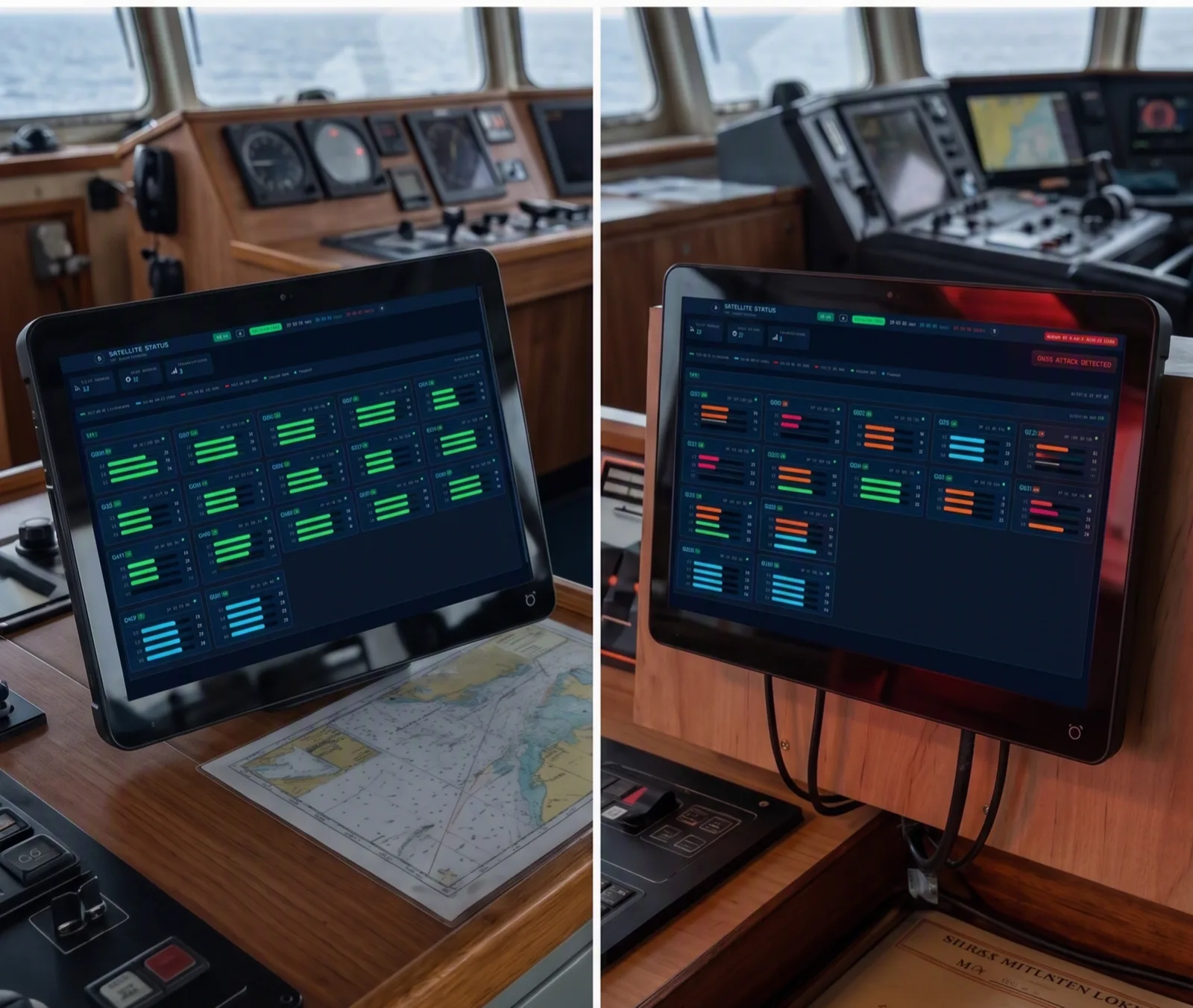
What is happening in the Baltic
On 26 January 2026, fourteen European coastal states — from Iceland and the United Kingdom to Finland and Poland — signed a joint letter warning that GNSS interference is degrading the safety of international shipping, above all in the Baltic Sea region. They called on authorities and industry to recognise GNSS interference and AIS manipulation as threats to maritime safety and security.
Measurements at sea back the warning up. A research vessel operating out of Gdańsk in the southern Baltic between June and October 2025 recorded GPS L1 spoofing alongside simultaneous jamming of Galileo, GLONASS and BeiDou. Across late June and July, GNSS availability on board fell to 83.5%, with one stretch of nearly 30 hours of spoofing inside 48.
It reaches navies as much as merchant ships. On 21 August 2026 the Polish minehunter ORP Albatros was jammed during operations in the Baltic, as NATO’s Joint Force Command Brunssum confirmed.
Jamming is loud. Spoofing is quiet.
Jamming drowns the satellite signals in noise. The receiver loses its fix, alarms sound, and the bridge knows it has a problem. It is disruptive, but it is honest.
Spoofing is different. A spoofer transmits forged, satellite-like signals, and the receiver keeps reporting a position — just the wrong one. Nothing fails, so nothing alarms, and the false position flows into everything downstream: the ECDIS plot, the AIS report, the autopilot. As the classification society IRClass put it in its June 2026 guidance, ships relying on satellite navigation may appear at incorrect locations on the ECDIS or on navigational charts.
That is why the pattern recorded in the southern Baltic matters. Jam every other constellation, spoof GPS, and a standard receiver has only the forged signal left to use.
| GNSS jamming | GNSS spoofing | |
|---|---|---|
| What it does | Drowns the satellite signals in radio noise | Broadcasts forged, satellite-like signals |
| What the receiver does | Loses its fix | Keeps reporting a position — the wrong one |
| What the bridge sees | Signal-lost alarms, no position | A normal-looking position, often with no alarm |
| ECDIS, AIS, autopilot | Position missing | False position passed on as if it were real |
| How it gets caught | Straight away — the receiver says so | Only by cross-checking against radar, visual bearings and charted features |
| What DIDI GNSS does | Rejects jamming by direction — up to 80 dB with the Sentinel antenna | Authenticates every signal; the Trust Score drops to Spoof |
Where it hits hardest
IRClass’s Technical Circular 012/2026 lists the waters where GNSS interference is particularly hazardous:
- Coastal waters
- Restricted or confined waters
- Traffic separation schemes
- Approaches to ports and harbours
- Pilotage waters
That is a description of a Baltic short-sea route. A corridor like Gdynia → Klaipėda runs through the southern Baltic and ends in a port approach — interference on exactly the leg where the margin for error is smallest.
What the crews on our sea trials saw
DIDI GNSS has been sea-trialled aboard three vessels in the eastern Baltic interference zone: the Silver Pearl on the Gdynia → Klaipėda corridor, the Laura and the Hjördis. The units have now been on board for more than three months, and the crews describe the same shift — from guessing when to stop trusting the position to seeing it happen.
"We cross the interference zone on every voyage. With the Trust Score on the bridge we finally see it happening — instead of guessing when the position can still be trusted."
Master · Silver Pearl
"It flagged interference our standard receiver showed nothing about. Being warned early — before it reaches ECDIS — has changed how we stand the watch."
Master · Hjördis
"The position is there, and now we know exactly how much to trust it. On a busy bridge, that confidence is worth a great deal."
Officer of the watch · Laura
What bridge teams can do now
The guidance converges on a handful of habits, and none of them needs new equipment:
- Don’t rely on GNSS alone where accuracy matters — fix the position by radar ranges, visual bearings, parallel indexing and dead reckoning, and fix it more often in coastal, confined and pilotage waters
- Cross-check the GNSS position regularly against radar, visual references and charted features, and investigate any discrepancy rather than explaining it away
- Know the warning signs: a sudden unexplained position jump, speed or course that doesn’t match the ship, ECDIS, radar, AIS and the view from the window disagreeing, frequent receiver alarms
- If interference is suspected, switch to alternative methods straight away
- Review the procedures in your SMS and train watchkeepers for navigating through interference
The fourteen-state letter asks the same of shipowners in its own words: adequate backup capabilities, and properly trained crews to operate during navigation system outages. We would add one habit of our own — log every event with its time, position and what the equipment showed. That record is what insurers, port state control and flag state ask for afterwards.
Where DIDI GNSS fits
Every habit above depends on the bridge noticing that something is wrong. A standard receiver cannot help with that: it reports a position with the same confidence whether the signal is genuine or forged. DIDI GNSS is built for exactly that gap.
- A live 0–100 Trust Score on every fix, so the drop from Trusted through Caution to Spoof reaches the officer of the watch while there is still time to act
- Cryptographic signal authentication that exposes forged satellites at the source
- Protection by direction — the Sentinel variant’s active antenna resists up to 80 dB of jamming from ships, shore, drones and aircraft
- Every event logged with its timestamp and signal data
DIDI GNSS is in its Early Access Programme, with first deliveries planned for Q1 2027. Reserving a place in the first delivery cohort costs nothing and commits you to nothing.
About this article
- Category
- Navigation
- Published
- Oct 2026
- Read time
- 6 min read
More from News
All articles
Take the riskiest routine off your bridge this quarter.
Tell us about your fleet and routes. A maritime engineer — not a sales script — confirms fit, pricing, and a non-intrusive rollout.